
The maps listed below were devised over the past 20 years to accompany particular articles or for use as handouts in lectures. The maps were drawn by the late Reginald Piggott, of Potter Heigham, Norfolk, whose distinctive style (represented by his elegant calligraphy, and by various aspects of cartographic design) can be seen in many books published in the last fifty years by various presses (notably the Cambridge University Press). All of the original maps (drawn on artist’s board) are available as image files, and may be downloaded for personal use from the links below. Should any map be wanted for purposes of publication, high resolution files are available here. Production of the maps, over the years, has depended on the support given to its fellows by Trinity College, Cambridge, for purposes of teaching and research.
SDK
May 2012
Click a map to open it in the viewer, where the mouse wheel and the + and − buttons zoom in; “Download” saves the full-size image.
 1997View ↗
The political development of Anglo-Saxon England
The sequence of maps shows how matters changed from the days of the so-called 'Heptarchy' (c. 700), past the period of the 'Mercian Supremacy' (c. 800), to the kingdom 'of the Anglo-Saxons' (c. 900) and thereafter to the kingdom 'of the English' (c. 1000).
Made in 1997, for the Blackwell Encyclopaedia of Anglo-Saxon England (Oxford, 1999), though re-drawn on four pages by the publishers, pp. 517–20.
 2012in preparationView ↗
Bede’s Britain (c. 700)
Showing how Britain is represented in the pages of Bede's Ecclesiastical History, with the addition of some other significant information.
Made in 2012, for general purposes. Not yet available.
 1994View ↗
Map showing the probable location of Clofesho
Clofesho was designated the meeting-place for church councils in the late seventh century, and was still used for such purposes in the 820s. It is likely to be somewhere on this map, but its exact location remains a mystery.
Made in 1994, for The Councils of Clofesho, Brixworth Lecture 1993 (Leicester, 1994).
 2000View ↗
Southern England in the eighth century
Explanatory comment to be added. Made in 2000, and published in Æthelbald and Offa: Two Eighth-Century Kings of Mercia, ed. D. Hill and M. Worthington (Oxford, 2005), p. 9 (reduced).
 1998View ↗
Southern England in the ninth century
Explanatory comment to be added. Made in 1998, and published in Alfred the Great, ed. T. Reuter (Aldershot, 2003), p. 187 (reduced).
 1996View ↗
From England to Rome in the ninth century
Explanatory comment to be added. Made in 1996, and published in Alfred the Wise, ed. J. Roberts, et al. (Woodbridge, 1997), p. 102.
 in preparationView ↗
The Viking invasions of Wessex
Explanatory comment to be added. In preparation. Cf. S. Keynes & M. Lapidge, Alfred the Great (Harmondsworth, 1983), Maps 1–3 (pp. 59–61).
 1996View ↗
The ‘Kingdom of the Anglo-Saxons’
Explanatory comment to be added. Made in 1996, and published in Kings, Currency and Alliances, ed. M. A. S. Blackburn and D. N. Dumville (Woodbridge, 1998), p. 32.
 1998View ↗
England during the reign of King Edward the Elder
Explanatory comment to be added. Made in 1998, and published in Edward the Elder, ed. N. Higham and D. Hill (London, 2001), pp. 46–7.
 1991View ↗
The contexts of the Fonthill Letter
Explanatory comment to be added. Made in 1991, and published in Words, Texts, and Manuscripts, ed. M. Korhammer (Woodbridge, 1992), p. 79.
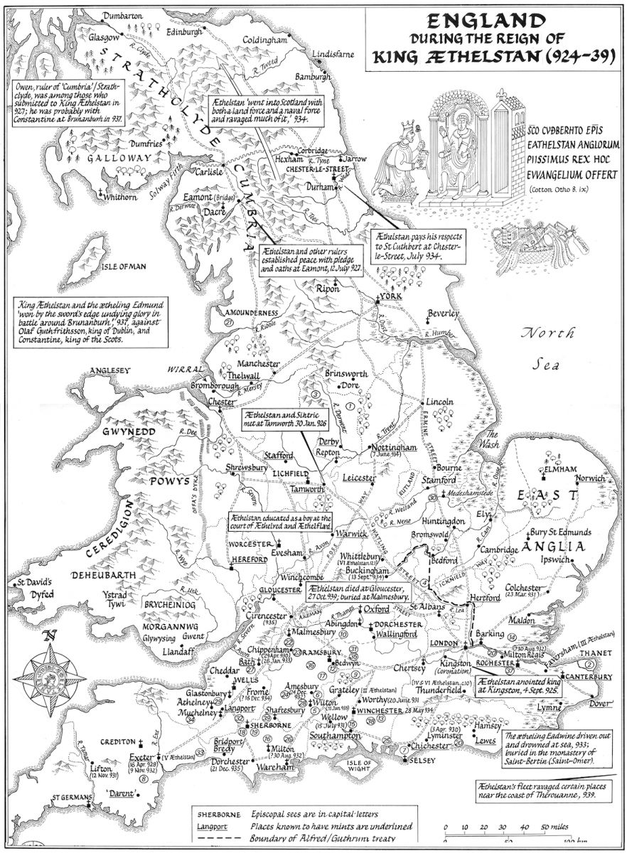 2001View ↗
England during the reign of King Æthelstan
Made in 2001, for the Toller Lecture (2001); not yet published.
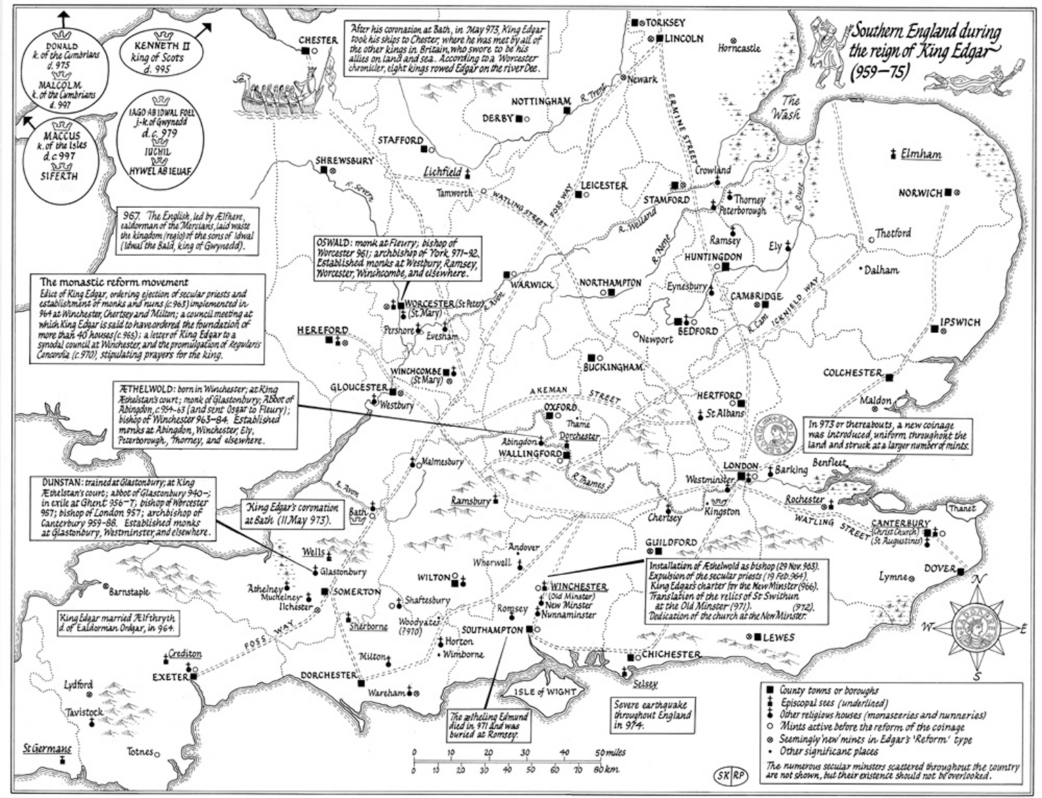 2008View ↗
Southern England during the reign of King Edgar (959–75)
Explanatory comment to be added. Made in 2008, and published in Edgar, King of the English, ed. D. Scragg (Woodbridge, 2008), opp. p. xvi.
 2006View ↗
Meeting-places of the king and his councillors, 900–1066
Explanatory comment to be added. Made in 2006, for an article forthcoming, superseding map published in The Diplomas of King Æthelred (Cambridge, 1980), p. 36.
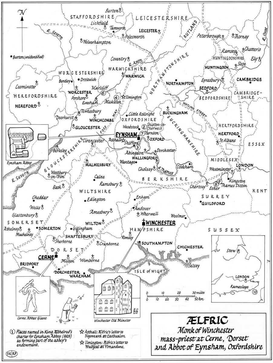 2006View ↗
Ælfric, monk of Winchester, mass-priest at Cerne, Dorset, and Abbot of Eynsham, Oxfordshire
Explanatory comment to be added. Made in 2006, for an article on King Æthelred’s charter for Eynsham Abbey; not yet published.
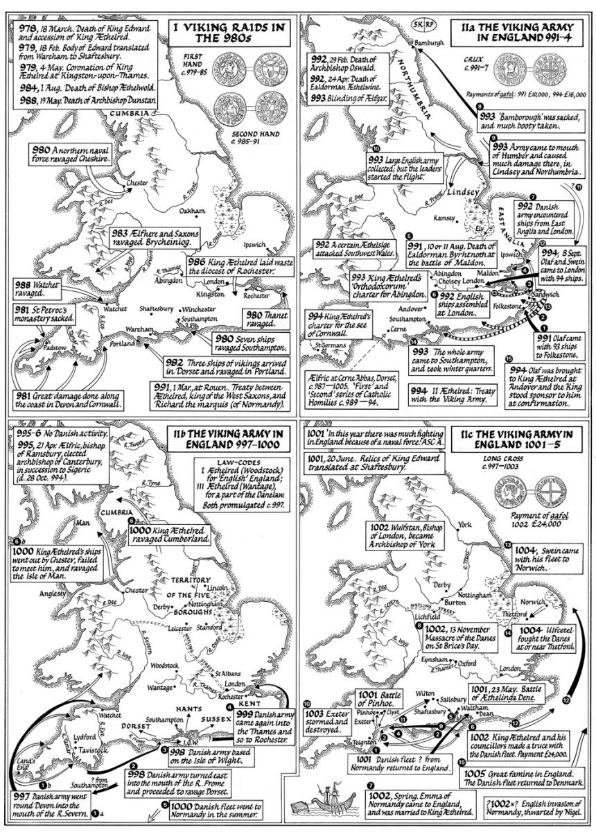 1999View ↗
Viking activity during the reign of King Æthelred the Unready, Maps I–IIc
Explanatory comment to be added. Made in 1999, for general purposes.
 2002View ↗
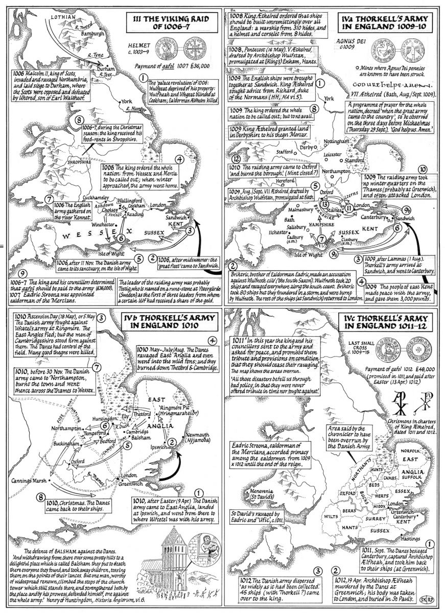
Viking activity during the reign of King Æthelred the Unready, Maps III–IVc
Explanatory comment to be added. Made in 2002, for general purposes.
 2002View ↗
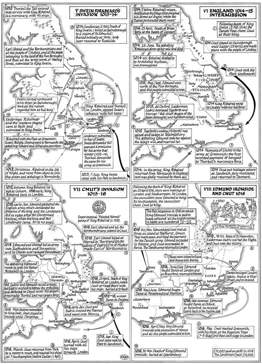
Viking activity during the reign of King Æthelred the Unready, Maps V–VIII
Explanatory comment to be added. Made in 2002, for general purposes.
 1991View ↗
Viking campaigns in England 991–1005
Explanatory comment to be added. Made in 1991, and published in The Battle of Maldon, AD 991, ed. D. Scragg (Oxford, 1991), p. 87.
 1997View ↗
Places named in the surveys of the Archbishop of York’s estates at Sherburn-in-Elmet, Otley, and Ripon, c. 1020
Explanatory comment to be added. Made in 1997, for reprint of an article published in The York Gospels, ed. N. Barker (London, 1986), p. 85; published in Wulfstan, Archbishop of York, ed. M. Townend (2004), p. 185.
 1996View ↗
Estates of the bishops of Wells
Explanatory comment to be added. Made in 1996, and published in Anglo-Norman Studies 19 (1997), p. 250.
 1997View ↗
Churches and estates belonging to Regenbald of Cirencester, priest and chancellor
Explanatory comment to be added. Made in 1997, for reprint of an article published in Anglo-Norman Studies 10 (1988), p. 194; not yet published.
No map matches.